The Colorado Plateau Coring Project: Getting Dates in the Triassic

Yesterday I wrote about how rocks layers are aged. After rock layers are lined up and put in relative order, they are dated radiometrically to get their age in years. Terrestrial rocks are difficult to date using relative ages alone, because the divisions of geologic time are defined based on changes in marine fossils (like ammonites and conodonts), which are rare in terrestrial rocks. We can make rough correlations if terrestrial layers are bracketed above and below by marine layers, which happens when sea level rises and oceans spill onto the edges continents. But the oceans reach continental centers rarely, so long stretches of time may occur between the marine “brackets” that allow terrestrial correlations.
A lot of neat stuff has happened on land during the history of life, from the birth of flowering plants to the origins of humankind. If we had a better grasp on the exact dates that these important events happened, then we could place them in context of things happening elsewhere on the planet: volcanic eruptions, asteroid impacts, climate change, etc.
One time of particular interest is the Triassic Period. Not only is it bounded by two enormous mass extinctions, but the Triassic is when all the major groups of land vertebrates alive today got their start: the ancestors of crocodiles and birds, frogs and salamanders, mammals and lizards all first appear or begin to diversify in the Triassic. What caused this burst of diversity – recovery from the biggest mass extinction of all time, climate change, rifting continents, or something else? How long did it take – was it simultaneous around the world or region; did it have pulses? The answers are in the rocks, but unfortunately, Triassic terrestrial rock layers are poorly correlated and poorly dated compared to other parts of the global geologic column.
![]()
Enter the Colorado Plateau Coring Project. The Colorado Plateau is an area covering about 130,000 square miles of Utah, Colorado, Arizona, and New Mexico. It’s well known for its dramatic geology and incredible national parks, including the Grand Canyon, Arches, Canyonlands, and Petrified Forest. It’s also rich in Triassic rocks and fossils. If the Colorado Plateau was better aligned to the global rock record and better dated radiometrically, it would be key to answering those questions above. The Colorado Plateau Coring Project (CPCP) is funded by the International Continental Drilling Program (ICDP)-funded and National Science Foundation to do just that.
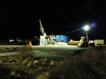
Petrified Forest National Park preserves an especially rich record of the terrestrial Triassic, and comprises nearly 100 million years of continuous rock layers, many rich in fossils. So it makes sense that the CPCP would begin their alignment and dating efforts here. This is a large, collaborative project involving scientists at several universities: Randall Irmis (University of Utah; Natural History Museum of Utah), George Gehrels (University of Arizona), Paul Olsen (Lamont-Dougherty Earth Observatory, Columbia University), Dennis Kent (Rutgers University), John Geissman (University of Texas at Dallas), and Roland Mundil (Berkeley Geochronology Laboratory). For the past two weeks, the team has been at Chinde Point in Petrified Forest drilling a core half a kilometer deep to get the basic rock data to align and date the Colorado Plateau.
Last week, I interviewed Randall about the details of this important research project.

SW: What are the main goals of the CPCP?
RI: The CPCP aims to recover a nearly-continuous record of sedimentary rocks from the Early Mesozoic (252-150 million years ago) of the Colorado Plateau. This record will be recovered using continuous rock cores recovered from at least five different locations around the plateau. Our first stage is to core the entire sequence of Triassic sedimentary rocks at Petrified Forest National Park; these are the Chinle and Moenkopi formations.
SW: What are you hoping to learn? Will the CPCP tell us anything about the biology of extinct animals or climate change?
RI: We hope to answer the following major questions:
- What is the tempo of climatic and biotic change during the Triassic, such as the rise of dinosaurs?
- How did changes in greenhouse gases (e.g., CO2) affect ecosystems and the environment during the Triassic Period?
- What caused a sudden change in plant and animal species at about 215 million years ago – could it have been a meteorite impact that hit Quebec at about the same time?
- How do Triassic ecosystems and environments in western North America compare with those from the same time in eastern North America, Europe, South America, and Africa?
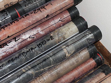
SW: What is a core – is it a common way to study rocks? Do you find fossils in the cores?
RI: Cores are basically columnar cylinders of rock drilled from a borehole using a diamond-studded bit, which is hollow in the middle. Cores are a common way to study subsurface rocks in the petroleum and economic geology industry. They’re also the primary way we study deep sea sediments. However, the application of scientific drilling (i.e., not for industry) to continents has been a fairly recent phenomenon. Fossils can be found in the core, particularly invertebrates and microfossils, but the primary goal of the core is not to recover vertebrate fossils.
SW: What do you do with this column of rock once you have it?
RI: We can do almost everything with the core that one would do with traditional rock samples from surficial outcrops. The first step is to characterize the stratigraphy and sedimentology – to understand where in section we are and what depositional environments are represented. The core is precisely oriented relative to both north and vertical, which allows us to look at paleomagnetism to develop a magnetic polarity stratigraphy. We will take samples for radioisotopic dating, organic and inorganic geochemistry, etc.
SW: Where will most of the research take place?
RI: Once we finish drilling, the cores will go to University of Texas-Austin to be CT scanned. They will then travel to LacCore at University of Minnesota where the cores will be split in half lengthwise, imaged, and analyzed for natural gamma radiation and other variables. One half will be permanently archived at LacCore, and the other half will go to Rutgers University where the science party will meet to describe the core and sample it. Most of the actual research will happen at a host of different institutions, including but not limited to Columbia University, Rutgers University, University of Texas-Dallas, University of Arizona, Berkeley Geochronology Center, University of Utah, and University of Oslo. In addition to the PIs (Paul Olsen, Dennis Kent, John Geissman, George Gehrels, Roland Mundil, and myself), a number of graduate students and postdocs are involved in the project, and I’m sure undergraduates will be involved as well.
SW: How does coring differ from traditional paleontology fieldwork?
RI: The timeframe of drilling varies greatly, depending on the characteristics of the rock and how long of a core you want to drill (or how many cores). This core will be somewhere between 450-500 meters long, and we expect it to take a couple of weeks to drill. One big difference from traditional fieldwork is that drilling occurs 24 hours a day, 7 days a week. The equipment is so expensive that it’s best to maximize time on the site. We work in two twelve hour shifts – in this case one from 8am to 8pm, and another from 8pm to 8am. The crew consists of two to three drilling staff from the contracted drilling firm, and 3-5 folks on the science team who log and process the core as it comes out of the ground.
SW: Why can’t you get these data from looking at rocks on the surface?
RI: The two main keys to the core are that it gives you unambiguous stratigraphic superposition, and completely unweathered fresh rock. What the first point means is that you know that you have a single column of rock and don’t have to worry about inferences from horizontal stratigraphic correlation. In most cases the advantage of the core over sampling surficial outcrop is data quality and resolution. For detailed sedimentologic/stratigraphic, paleomagnetic, and geochemical sampling, one would have to dig trenches at least 1-2 meters deep to reach fresh unweathered rock. The time it takes to do this limits the density of sampling to a couple of samples per meter at best, and would take many months to complete over the ~450 meters of section we are coring. One other main benefit of our core is an innovation of my co-PI Dennis Kent – drilling the core at a 30° angle from vertical. This means we can very precisely orient the samples for paleomagnetic work, and it gives us more rock per stratigraphic layer, which is useful when you’re taking so many samples from a 2.5 inch diameter core.
SW: Why hasn’t coring been attempted before?
RI: The proximate reason is cost – this core costs just under US $1 million, and that doesn’t include any of the science we’ll be doing. That being said, scientific continental drilling is quickly becoming more common in deep time rocks (i.e., before the Pleistocene), particularly as specific funding sources for these types of projects are becoming available. A broader answer is that as scientists refine their scientific questions, we need better age control and data resolution, so we haven’t necessarily needed the resolution provided by coring until recently.
SW: Why did you start with Petrified Forest?
RI: We wanted to start with a core that was both logistically manageable and maximized integration of existing data. Petrified Forest National Park has been a great partner in the project, and has been very supportive the entire way. They’ve provided housing for the science team, and encouraged visitors to stop by to learn about CPCP. We’re drilling in the gravel parking lot at Chinde Point, so its easy to get equipment/personnel in and out, and that way we’re also not adversely affecting any park resources. The Triassic rocks at Petrified Forest NP and surrounding areas have been well-studied for quite a while, so there’s a very large dataset of environmental and paleontologic information that we can immediately integrate with the core to get a holistic picture of the story during the Middle and Late Triassic.
SW: How many of these cores do you have scheduled and where else are you going to drill?
RI: Currently we are focusing on the first core at Petrified Forest National Park, which will cover nearly all of the Upper Triassic Chinle Formation and all of the Lower-Middle Triassic Moenkopi Formation. Some late-breaking news is that we’ve just received additional supplemental funding from the International Continental Drilling Program (ICDP) to drill a second shorter core in the Chinle Fm in the southern part of the park. This will allow us to precisely test using geochronology the stratigraphic correlations that have been proposed between the northern and southern part of the park, and therefore also test the biostratigraphic schemes built on these correlations (e.g., Parker & Martz 2011). This is particularly relevant for understanding the biotic turnover at ~215 Ma that might correlate with the Manicouagan impact event in Quebec. In the longer term, we have plans to core a total of five sites across the Colorado Plateau, which span rocks that range in age from 250 million years old to 145 million years old. Coring of these future sites will require additional separate funding.

SW: Who is funding the CPCP, and how long did it take to get the money together for such a big endeavor?
RI: The Petrified Forest core is graciously funded by the National Science Foundation and International Continental Drilling Program. Just the costs associated with the drilling alone are almost US $1 million. The project was initiated with workshops in 2007 and 2009, and we submitted our first proposals for funding in late 2009.
SW: Are there economic benefits or museum exhibits planned? Will the research benefit people outside the sciences?
RI: There are definitely plans for a strong component of outreach and communication about the results of the project, through exhibits and public programs at Petrified Forest National Park as well as at each PI’s individual institution. In fact, the drilling site itself can be visited by anyone who is visiting the park – so we’re an active ‘living exhibit’ at the moment. The research that will come out of the core has direct societal benefits in that it will elucidate how ecosystems change in a warming world with high CO2, something we all face with anthropogenic climate change over the next century. The project directly or indirectly supports dozens of jobs in the drilling industry, both through the drilling contractor itself as well as a wide variety of sub-contractors for everything from drilling mud to water supply to rental of generators and work lights.
SW: Thanks so much for all your time, Randy! How can we keep track of CPCP progress between now and publication?
RI: The best way to follow the CPCP is via our Facebook page and blog. I should give a shout out to Steven Seppi for designing the beautiful project logo.
——-
Literature cited: Parker WG and JW Martz. 2011. The Late Triassic (Norian) Adamanian-Revueltian tetrapod faunal transition in the Chinle Formation of Petrified Forest National Park, Arizona. Earth and Environmental Science Transactions of the Royal Society of Edinburgh 101: 231-260.